Portfolio
A closer look at the maps, tools, and visuals we've built for public lands organizations.
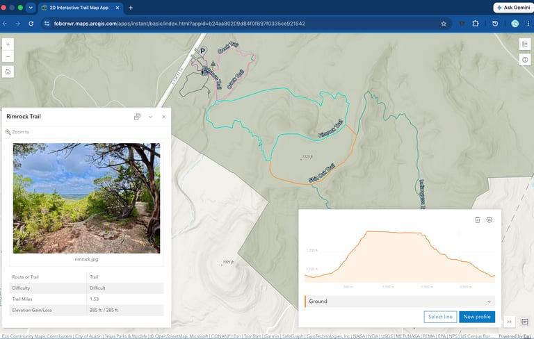
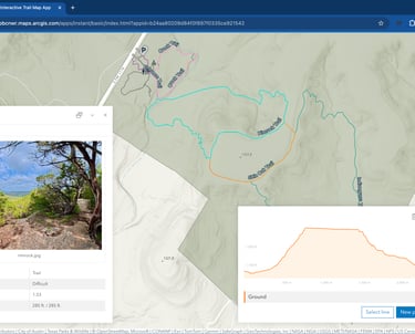
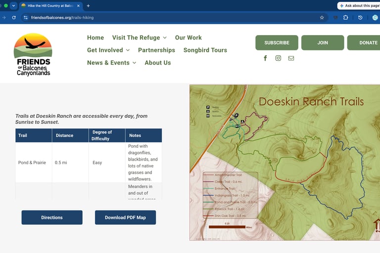
Interactive Trail Map / GeoPDFs
Trail Maps for Four Public Use Areas
The Friends of Balcones Canyonlands NWR sought to enhance their new website with more engaging content about the refuge. With three public use areas featuring scenic trails, they aimed to expand public outreach as part of their Nearby Nature campaign.
GIS For The People developed an interactive trail map and downloadable GeoPDF maps to support this initiative. The interactive map allows users to zoom into each public trail area and explore trail details, including length, difficulty, and photos. The downloadable GeoPDF maps provide comprehensive trail information and are geo-coded for offline navigation using free apps like Avenza.
Looking ahead, the next phase involves collaborating with AllTrails® through its partnership with the Public Lands Alliance to update trail listings and install QR code trailhead signs, enabling visitors to access trail details on the AllTrails app.
360° Virtual Tours
Trail Maps for Three Public Use Areas
The Friends of Balcones Canyonlands NWR, in collaboration with the refuge, are developing two mindfulness trails—one along the scenic creek at Doeskin Ranch and a new fully accessible trail at the Shin Oak Observation Deck.
The addition of the refuge's first accessible trail sparked conversations about how to share the beauty of more rugged areas with visitors who may not be able to explore them in person. At the same time, it highlighted a need to better showcase the existing public trails.
To meet both goals, GIS for the People proposed creating virtual hikes using 360-degree panoramic photography. The Creek Trail served as the pilot project, and plans are now underway to expand this virtual experience to other public trails throughout the refuge.
Click on the image to view a virtual hike of the Rimrock Indiangrass Loop
Advocacy Map / Donor & Press Outreach
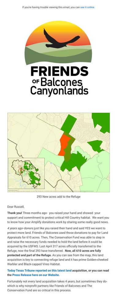
Mapping a Refuge's Growth, for Donors and the Press
When Friends of Balcones first asked donors to help protect critical Hill Country habitat, it set off a four-year process — donations funded land appraisals, while The Conservation Fund raised the additional funds needed to hold the property until the U.S. Fish and Wildlife Service could complete the purchase. The acquisition came together in two phases, first 317 acres and then 293 more, ultimately adding over 600 acres of habitat that connects to existing refuge land and protects key nesting ground for the golden-cheeked warbler and black-capped vireo.
GIS For The People created the map used to show donors exactly what their support achieved. That same map anchored the donor newsletter explaining where four years of contributions had gone, was later featured in a Texas Tribune story on the expansion, and continues to appear in member event materials — a clear example of how one well-designed map can carry an organization's story across donor updates, press coverage, and everything in between.
Mobile App / Field Tools
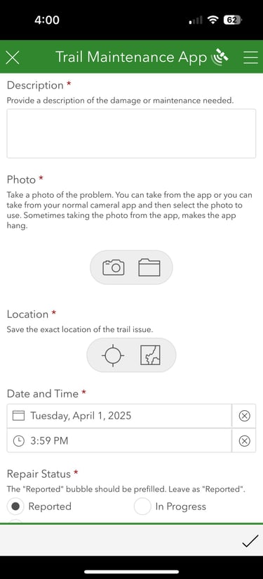
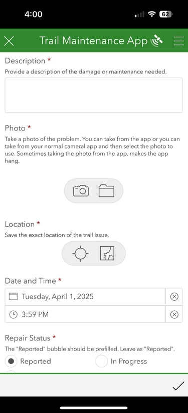
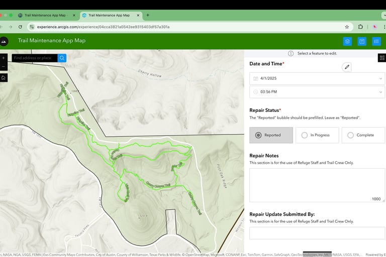
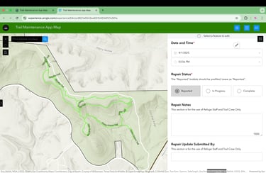
Trail Maintenance Reporting App
GIS For The People collaborated with the Friends of Balcones Canyonlands NWR to develop a trail maintenance reporting app, streamlining the process of identifying and tracking repairs for public trails on the refuge.
Compatible with iOS and Android, the app enables refuge staff and volunteers to log maintenance issues by adding descriptions and photos, with automatic location tagging. A map-based dashboard allows users to view reported issues, update their status, and track repair progress, improving efficiency in maintaining the refuge’s trails.
Pint / Promotional Materials
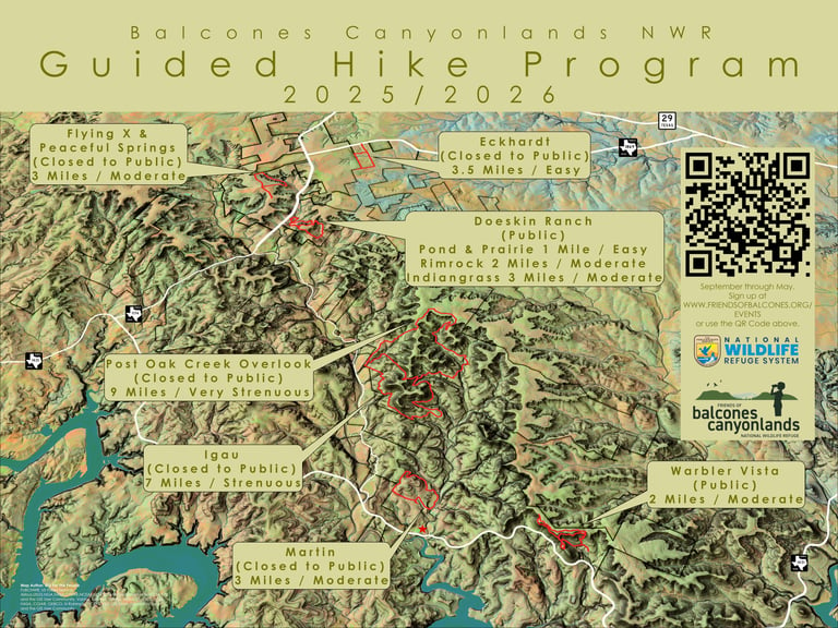
Guided Hikes Promotional Poster
In partnership with the refuge, the Friends of Balcones Canyonlands NWR offer free Guided Hikes to the public, providing access to both designated trails and select non-public areas. To support outreach efforts promoting recreation and wildlife management, the refuge needed a promotional poster for its headquarters.
The Guided Hike Program hosted 40 hikes with 821 participants last season and is now serving as a model for other refuges looking to establish similar programs.
Ready to Map Your Impact?
Let’s explore how GIS can help your organization make a difference.